ME 27(2001.0) to East Flagstaff Lake Campsite(2018.8) 17.8 Miles

Maine reminds me of that crappy boyfriend you are about to dump. You're sick and tired of the way he treats you and you don't see any redeeming qualities in him. Just when you're getting ready to pull the trigger and breakup with him, he does the most amazing thing. You start to think that maybe you were too hasty and you decide to give him a second chance. From this point on he is on super secret probation. That is exactly how Maine has been for me. I thought this state was going to be great. I'd already put in the hard work and figured I could cruise through until the end. Then Maine decided to be an ass. It has treated me horribly. All these ups and downs, wet and slippery rocks, and not a single switchback to be had. Well today was Maine's way of trying to get me to not dump it. Yes, it was a brutally difficult day, but it was also an amazingly beautiful day. So from here on out, Maine, you're on super secret probation. I'll decide when this is all over if there was enough redeeming qualities for you to be a keeper.
I was up at 5:30 this morning, but since my roommates were still asleep I didn't get up right away. Uncle D, who I had never met, but knew about from Airlock, and Quahog, who I haven't seen since Mt. Rogers visitor center in VA, were staying in the same bunkroom as me. We stayed up way past hiker midnight. Uncle D was making arraignments for his wife to come meet him at the end of the trail, Quahog was watching movies in the common room, and I was catching up on my blog. I finally got up at 6:00, I was anxious to get started on the trail today. South Paw told me about an amazing campsite and if I wanted to make it there I had to do an eighteen mile day over some really big mountains. I knew I'd need all of the day to make it there.

The shuttle back to the trail wasn't scheduled to leave until 8:00, so I decided to hitch back. The first car to stop was a van full of nine Hispanic men. There wasn't even a place for me to sit. They all agreed that I could just sit on someone's lap. Well, that's not creepy at all!!! I said, thanks but no thanks. A few minutes later an old school VW bus pulled over. The guy seemed familiar with picking up hikers, so I hopped in. The only thing wrong with him was his LSU hat. After only a few minutes he had me dropped off next to the trailhead. Another successful hitch!
The trail started off very easy. I cruised through the first two miles in less than an hour. Unfortunately, it didn't stay easy for very long. While I was still on the easy section I made a major mistake, I passed up two really good water sources. That would come back to bite me in the butt later in the morning. My trail guide showed that I had plenty of reliable water sources throughout the day, but it was wrong. The water sources I came across were all dry or had signs posted saying that hikers had reported getting sick from that area. The signs suggested filtering and using chemicals before drinking. I only have a filter now, I haven't used Aqua Mira drops since New Jersey, so I don't carry that anymore.
I had a ridiculous steep climb to Horns Pond Lean-to. By the time I got there I was really thirsty and had drank half of my water. I had planned on filling up there, but the spring was dry. There was a pond there were I could have gotten water, but it was off of the trail and I didn't want to take the time to get it. I thought there would be more water a little farther down.


At this point I still wasn't too concerned about the water situation. I had over half of a liter and there were plenty of water sources listed in my guide. The climb up the Horns wasn't as bad as I expected, but that's not saying much. These days I always expect the trails to be steep and to include boulder scrambles.

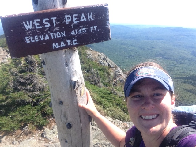
After climbing up South Horn the trail went down a few hundred feet, only to go back up several hundred feet. I didn't really mind this climb. Everyone talks about how amazing the view is from the west peak of Bigelow Mountain and it lived up to the hype. The climb up to the west peak wasn't anything I haven't done before. It was steep and involved some rock scrambles, but it's been such nice weather lately the rock scrambles were actually fun.


The trail descended from West Peak, only to go right back up to Avery Peak. The climb up, Avery Peak, was also difficult and taxing, but once again I got great views.

Avery Peak gets its name from, Myron Avery. Avery was one of the driving forces behind the creation of the AT.

Avery Peak of the Bigelow Mountain Range marks the last time until Katahdin that the trail goes above 4,000 feet. Which means that I won't be above treeline again until I finish the trail.
Now the unfun part of my day began. I had a three mile descent from Bigelow Mountain. After the five mile descent yesterday my knees were still hurting. It wasn't long until they were on fire. I was also almost out of water. All of the sources I came across were dry. It was getting hotter out by the minute and I was quickly becoming dehydrated. By the time I reached the end of the downhill I was parched. My trail guide said I was one mile from a reliable water source, so I pushed myself hard to get there. When I arrived at the spring I knew I was in trouble, it was almost dry. It was really just a puddle. I didn't really have another option, I had to use it. This is the first time I have collected water from a source that wasn't flowing. I guess in 5-7 days I'll know if that was a mistake.

The climb up to Little Bigelow Mountain was supposed to be a nice gradual uphill, but it sure didn't feel like that. Maybe it's because I let myself get dehydrated, or maybe it was my lack of calories, but that climb sucked. On paper it didn't look like much, but in reality it was a lot of steeps ups, followed by short downs. I was glad to finally make it to the top, even if it wasn't the greatest view.

My day ended with another three mile downhill. At this point I was utterly drained and my knees and ankle were shot. I'm still not sure how I made it all the way down without falling.
I finally made it to the campsite that, South Paw, had told me about. I'm camped next to the shore of Flagstaff lake. I even have the place all to myself. With this being Labor Day weekend, I expected the lake to be packed. I guess I just have good timing. I quickly set up camp before heading down to the lake for dinner. This is my all time favorite camping spot. It was the perfect end to a hard, but beautiful day.


"Things turn out best for people who make the best of the way things turn out." John Wooden
Not good news about the water situation. Hope you are OK with what you had to drink from the puddle. The views are incredible and I love your positive attitude about the difficult ups and downs of today's terrain. Sunset is beautiful and to have the lake all to yourself is wonderful. Sounds like Southpaw gave you good advice about the location. Continue to travel well!
ReplyDeleteGreat analogy...and "Maine decided to be an ass" ....LOL was a great way to start my Saturday. I so enjoy your writing! The photos are fantastic...I was gagging at the thought of drinking puddle water. Thank you Thank you for sharing the actual and figurative ups and downs of your hike. Great stuff. (I feel like I need to ice my knees...)
ReplyDeleteCute analogy! Loved the halfway up the peak photo and the sun setting over the lake. XOXO
ReplyDeleteBeautiful pictures from your up & down day. I really like the view over the lake and the sunset. I didn't quite know where the analogy was going, but it was great. I enjoy the way you bring your days together with your sayings. I'm NOT happy about another hitch hike. Did they really think you would get in with nine guys and sit in lap!.... The lake was a nice ending to your day. I hope you soaked your ankle and got some decent water after collecting muddy water.
ReplyDeleteI hope there is no more hitching by yourself!! LY
ReplyDeleteFirst--Congrats on the 2000 mile accomplishment! Thanks for more awesome pics!
ReplyDeleteWhen "5 Million Steps With Yoda" hits the big screen, the scene with the van full of Hispanic men will be a hoot!
Hope your boyfriend is treating you better--be careful what you take to drink from him :)
You are so close to the finish, and I am sure you can't wait to reconnect with your family and relax...but here is something to ponder....... a continuation of the blog for a bit--- transitioning from trail life, and also your thoughts on things like your top 3 favorite places.....best hostels....best trail meals(that you cooked yourself),...best trail magic.. scariest moments(the men with ATV's driving up to your stealth site comes to mind)....and how you feel like you have changed since April.
Are you serious about the PCT next year?
Stay safe and healthy, and best of luck as you get closer to the finish!
Kathy....."the worrier"
Hope the water works out. It's been hot and muggy for this time of the year in our area of Maine. Did you know Flagstaff used to be a town and it is the largest man made lake in Maine? Here is a little history:
ReplyDeleteThe fate of the Dead River Valley’s lost towns was a product of the era of hydroelectric power in Maine. Walter Wyman and his company, Central Maine Power, began buying up small, local power companies in the early 20th century, consolidating Maine’s electricity production. Central Maine Power Company went on to build and operate a series of hydroelectric dams in Maine – but to do this, Wyman wanted to build a dam which would control the flow of the Kennebec River (Judd n.d.).
Originally, Wyman planned this dam at The Forks, where the Dead River meets the Kennebec. Wyman’s plans met with opposition by legislator Percival Baxter, who would later become governor of Maine. Ultimately, the Maine legislature chose to approve Wyman’s plan on the condition that he lease the state-owned lands his company would be flooding (Maine Public Broadcasting 2000). Because of the cost of leasing the land, Wyman looked toward an alternative – which included the construction of a dam at Long Falls on the Dead River, sealing the fate of two small towns in the Dead River Valley (Burnell and Wing 2010).
In 1930, Central Maine Power began purchasing the land that would be flooded. In 1948 and 1949, the company hired
crews to clear the flowage area. During the summer of 1949, smoke engulfed Flagstaff as the crews burned the brush that remained. A year after that, the Long Falls Dam had been completed, its gates shut, and the towns of Flagstaff and Dead River were under water. Some of the town's structures, like its schoolhouse, were razed; others were moved out of the path of the diverted Dead River; some, because their owners had not settled on compensation with Central Maine Power Company, remained standing as the flood waters rose in Flagstaff (Maine Public Broadcasting 2000).
More info: This should of gone before the above post.
DeleteThe village of Flagstaff, which took its name from the flagpole erected by Benedict Arnold’s men during his famous march, drew its first permanent settlers in the early 1800s. Settlers came for the soil of the Dead River floodplain, the power available from the outlet of the naturally-occurring Flagstaff Pond, and especially the area’s rich timber resources (Burnell and Wing 2010).
In the 1840s, Myles Standish (a descendent of the pilgrim of the same name) built Flagstaff’s grist- and sawmills, which were powered by a small dam on the outlet, known as the Mill Stream (Lamb 2009). During the same time period, the area around Flagstaff Village was also being settled, including Dead River Plantation (Burnell and Wing 2010).
For the next century, the people of Flagstaff and Dead River lived and worked, went to school and raised families here - but the towns were flooded in 1949 as the result of the construction of the Long Falls Dam. Flagstaff Village was legally disincorporated, and its residents relocated (Maine Public Broadcasting 2000).
I "second" everything Kathy....."the worrier" said.
ReplyDeletePCT next year??? Oooooooo. yes! yes! yes! I'll be a individual sponsor!
Great sunset pic! Love that you had a nice place to end such a rough day! May the trail be nicer to you tomorrow AND water sources be better!
ReplyDeleteYou have always been an amazing person in my eyes and now to everyone following your blog. Keep it up! You are giving all of us great stories to share and great dreams to have.
ReplyDelete