Tuesday, June 28, 2016

Day 54- Finding Forester

June 25, 2016
JMT/PCT Junction(767) to Vidette Meadow Tentsite(787) 20 Miles plus 1.2 back to the PCT from Whitney 

What another fantastic day! We definitely had the true Sierra Nevada experience today. We postholed, glissaded, used our ice axes and microspikes, and had scary mountaineer type terrain. It was awesome. We actually stuck to our plan of getting up early and making it to Forester Pass before conditions became dangerous. The hike to Forester was amazing. It was difficult to make miles because we kept stopping to take pictures. We had a few stream crossings to deal with, but they were not too bad. We had to take off our socks and shoes to make it across, but they were perfectly safe crossings. 
Rocky meadow

To be perfectly honest we weren't even sure we were going to hike over Forester Pass today. We had two plans leaving camp. Plan one was to hike up and over Forester and camp at the first place we could find. Plan two was to camp at the base of the pass. We were all pretty worn out from climbing Whitney yesterday and we weren't sure we could do another high elevation climb so soon. Surprisingly we felt great and once we got close to Forester there was no doubt that we would proceed. 
Field of talus
One of many snow fields we had to navigate
Amazing scenery
I found Forester
That is Forester Pass! Just a tiny notch in the rock face
See the ice chute above my head? That is the pass
Walking across a frozen lake(one of the most dangerous parts of the day)

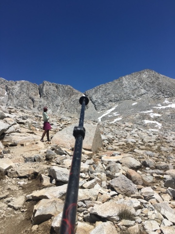
Shortly after this picture was taken we walked over a very thin sheet of ice. We were probably walking on less than an inch of ice/snow. About ten feet away from us there was flowing water. We all made it safely across, but it was a scary moment. The climb up to the pass was less than a mile, but was over 1,000 feet of elevation. I really enjoyed it! I like working hard for my beautiful views. 
Getting close to the top. The closest frozen lake is what we walked across

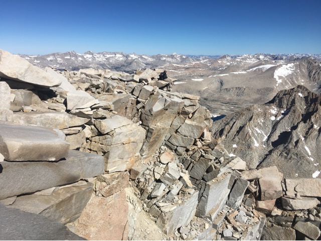
We made it to the top of the pass in under twenty minutes. Our last obstacle before reaching the top was the infamous ice chute. This is the main reason hikers carry an ice axe and microspikes. This is also the main reason we took our time in the desert. We wanted to wait for most of the snow to melt. Forester Pass is the highest point in the Pacific Crest Trail. It is at 13,200 feet. This makes the ice chute a very risky proposition. If you were to slip on the ice it is a very long way to fall. 
Don't look down

Outro was the first to go across. She made it look very easy. I was more than a little nervous. I put on my microspikes, but there wasn't enough snow to bother with my ice axe. I tentatively made my way across. It was an epic moment, definitely one of the most bad ass things I have ever done while backpacking. 
We all made it across safely and our adrenaline was really flowing. 
Safely navigated the ice chute
Left behind Sequoia NP and entered Kings Canyon
Large snow fields to navigate

I am really glad that I bought microspikes. They are absolutely amazing. I felt 100% confident walking across this snowy slope. It was very slow going and we kept post holing(breaking through the snow). Every step felt like a jack in the box, you never knew when your foot would break through the snow and you would sink in up to the upper thigh. It was very tiring. Eventually I had enough and glissaded down a few hundred feet. 
Looking back up to the pass

We crossed a few more snow fields and made it safely across to a ridge. We were absolutely floored by the stunning view. Kings Canyon is absolutely amazing. We stayed on top of the ridge for over an hour. We each took a million pictures from every angle possible. 
Taking in the view
Wolf Pack snack time
How lucky are we?
I have a million great pictures from this ridgeline

Another group of hikers caught up to us and told us about some trail magic located seven miles away. We had planned on stopping and camping in four miles, but just the idea of trail magic spurred us on. We had one more sketchy snow field to go through. Instead of post holing our way through it we took the easy way and glissaded down. 

Seven miles to go until trail magic sounded pretty easy, but in reality it was not. First of all it was seven miles of downhill. Second of all we had just climbed up to the highest point in the PCT and yesterday we climbed up and down the tallest mountain in the lower 48. I was TIRED! The thought of pasta and whiskey(the rumored trail magic) kept bouncing around in my brain. Also the spectacular scenery kept me relatively energized. 
I get to live here

Eventually we made it to the promised land. Upon entering Vidette Meadow we were greeted by a gentleman wearing a Canadian Mounties uniform. I never got the reason he was dressed in such a manor, but he gave me Jameson, so I didn't really care. 
Trail Magic!!!

To provide such a wonderful spread in the middle of Kings Canyon NP, these trail angels hired pack mules to bring in the supplies. I almost cried. I didn't make it in time for the pasta dinner, but they made me quesadillas and pumped me full of oreos. As the sun was setting over Vidette mountain two of the gentleman played a mournful duet on a guitar and flute. It was a magical moment to end a magical day. 
Vidette Mountain

"Oh, these vast, calm, measureless mountain days, inciting at once to work and rest! Days in whose light everything seems equally divine, opening a thousand windows to show us God. Nevermore, however weary, should one faint by the way who gains the blessings of one mountain day; whatever his fate, long life, short life, stormy or calm, he is rich forever."
- John Muir


Monday, June 27, 2016

Day 53- If A Picture Is Worth A Thousand Words

June 24, 2016
Mount Whitney side trip 15 miles
Elevation 14,496.811 feet

Mount Whitney at sunrise was one of the best moments of my life! It was a humbling experience to be at the highest point in the continental United States. Zuul, Outro, and I woke up at 11:30 and started to hike at 12:45 am to make it to the summit before sunrise. The seven and a half miles went by quickly. The higher we climbed the colder it got. Ultimately I was glad to be going up in the dark. It was way less scary not being able to see what I was actually doing. I knew that some of the climb was really sketchy, but it wasn't until later when I went back down that I knew how scary it was. 
Sign 2 miles from the top

About half way up the mountain I looked back down and could see headlights bobbing in the distance from all of the other hikers making the pilgrimage to the top. The last mile was very difficult and scary. I had to cross loose rock and several snow fields. In the back of my mind I knew that one wrong step would spell disaster, but I had adrenaline on my side. I practically flew up the last quarter of a mile. Once I was at the peak it was freezing cold. I tried my best to bundle up, but I was soaked with sweat. No matter how many layers I put on I was still cold. I had to wait about thirty minutes for the sun to rise over the distant mountains. The longer I waited the more hikers that showed up. Most of the people at the top I knew and it was a great moment to share with each other. The sky turned the prettiest orange and blue I have ever seen. 
So it begins
The sun and moon in the same picture
Yoda and Outro enjoying the moment
Me and The Neighborhood
Yoda pose
The Sierra Nevada Range
Muir Hut
My sleepy face
Sprinkles, Me, and Outro
Summit sign
Sitting on the ledge

Mount Whitney has a special rule about pooping, you can't do it on the mountain. This forced most of us off of the mountain. We had been up there for over five hours so it wasn't a big deal. We took one last group picture before heading down.

Over the course of five hours my mind had me convinced that the trip off of the mountain was going to be a death defying ordeal. Since I couldn't see anything on the way up my imagination filled in the blanks in the worst way imaginable. In the end there was only a few scary moments and a whole lot of beauty. 

So cool

We were almost to the switchback section of the climb down when we came upon a section hiker. He asked if anybody knew who Yoda was. I told him that I was Yoda. He had heard I was running low on food from another thru-hiker and wanted to make sure I had enough. He gave me two bags of beef jerky and a pound of almonds. That guaranteed that I would have enough to make it until our next resupply. 
Thanks for the food Reed
Guitar Lake(because it looks like a guitar)

Zuul and I had four or five switchbacks left to go when we came across a rather large snow field. We decided to take the quick way off of the mountain and glissade down. Imagine sledding down a mountain, but without a sled. It was so much fun!
Zuul glissading down

After over twelve hours of excitement I was physically and mentally exhausted. By the time we made it back to camp I resembled a zombie. I got out my tyvek and sleeping pad and laid down in the shade to take a nap. Unfortunately, I was too keyed up to sleep. Everyone decided to cook dinner so I joined the group. We decided to wake up early tomorrow so we could attack Forester Pass before the snow got too slushy. Forester Pass is the highest point on the PCT and has many challenges. I am excited to see if I am up to those challenges. 

"Another glorious Sierra day in which one seems to be dissolved and absorbed and sent pulsing onward we know not where. Life seems neither long nor short, and we take no more heed to save time or make haste than do the trees and stars. This is true freedom, a good practical sort of immortality."
John Muir, My First Summer in the Sierra


Friday, June 24, 2016

Day 52- The Approach To Mount Whitney

June 23, 2016 
Tentsite(755.3) to PCT/JMT Junction(767)  + .8 Mt Whitney Summit trail 11.7 trail miles. 12.5 miles total 

Today was a very rough day. I think it was a combination of muscle fatigue from yesterday and tough elevation gain/loss today. I hiked all morning and afternoon with Zuul. We left camp a little after six o'clock. I planned on taking my time today to give my legs a chance to rest before my midnight/sunrise summit of Whitney. I, however, did not plan on taking eight hours to hike twelve miles. There was just too much awesomeness to not stop and enjoy it. 
Hike out of camp

Leaving camp we immediately lost most of last nights elevation gain. We went from 11,000 feet down to 9,500. The camp spot at 9,500' was super cool, so I decided to take a break and make some coffee. Zuul and I chatted with Stork and Big Spoon for a long while before tackling the climb back up to 11,000 feet. 
First stream crossing

Before staring the climb we hit our first stream crossing. Since I had just taken a long coffee break I didn't feel like taking the time to take off my socks and shoes. I went straight through with zero problems. The ice cold water felt great on my sore feet. Our next break was at Guyot Creek, which was halfway up the mountain. We were running low on water so we sat down and had a snack while we filtered. We then went into beast mode and made quick work of Guyot mountain. We took another well deserved break at Guyot Pass. Guyot is named after Arnold H. Guyot(1807-1884), an Appalachian Mountains explorer and geology/geography professor at the College of New Jersey (Princeton).  
We used our break time to take fun pictures and to chat with another group of hikers. 
Might as well use the ice axe for something
Howling

Eventually, it was time to get moving. I really wanted to make it into camp early so we could try and get some sleep. After climbing up to Guyot we went back down immediately. Luckily, it was a short down and we didn't lose all of the elevation we had gained. Zuul and I didn't make it very far before we were brought up short by our first view of Mt. Whitney. To say that we were excited would be a huge understatement. 
There she is!!!! 

We were still determined to make it into camp early, but we came across a beautiful meadow that just begged us to stay for awhile. I took the opportunity to wash my socks and shorts in the ice cold stream that ran through the meadow. 
Whitney Creek 

Finally we tore ourselves away and finished the last mile and a half into camp. Outro was waiting for us there. She had powered through the miles and had been there for a long time. Zuul and I set up camp and tried to get some rest, but we were too excited to sleep(plus it was only two o'clock). We took the opportunity to plan our sunrise Mount Whitney summit. There were a lot of other hikers in the area who had just done their own sunrise Whitney summit. We asked all of them how long it had taken them. The general consensus was four hours would give us plenty of time. Last year on the AT I just barely missed the sunrise on Mt. Washington and I didn't want to risk that for Whitney. I decided to give myself five hours to make it to the top. Since the sun is rising at 5:30, I would have to be on trail by 12:30. Yikes, that didn't leave a whole lot of time for sleep. The problem was every time I tried to go to sleep friends who were ahead of me kept coming down from Whitney. Most of them I hadn't seen since Kennedy Meadows and I wanted to chat with them. 

By five o'clock we started to get concerned because the rest of the Wolf Pack hadn't arrived yet. We had expected to see them around three o'clock. Eventually Raging Pineapple strolled into camp with bad news. Last night Evac had gotten sick. She wasn't sure if it was the same stomach bug that people had gotten from Kennedy Meadows or if it was a form of altitude sickness. Wolf and Uturn had stayed behind to take care of her. Sprinkles and Homegrown showed up a little bit later. They decided not to do Whitney at sunrise. Raging Pineapple, Homegrown, and Sprinkles would leave at four o'clock for their summit. Zuul, Outro, and I headed off to try and get some sleep. We had to be up at 11:30 pm for our sunrise adventure. I didn't fall asleep until after nine o'clock. I guess I was just too excited(and a little nervous as well). 

"I only went out for a walk and finally concluded to stay out till sundown, for going out, I found, was really going in.”
- John Muir


Day 51- SEKI

June 22, 2016
Death Canyon Creek(730.8) to Tentsite(755.3) 24.5 Miles

We are getting really close to Mount Whitney now. Outro and I were taking a look at our maps and decided that in order to have a sunrise summit we would have to hike twenty miles today, twenty miles tomorrow, then sleep for 4-5 hours and hike eight miles to the summit. We decided to hike a longer day today, to make tomorrow more manageable. 

I attempted to get an earlier start this morning. I succeeded, but not by much. I started hiking around 6:45. I would have left earlier, but when I picked up my sunglasses they broke in my hand. It took me awhile to rig up a duct tape solution. The first part of the hike was another big climb, but I thought it was pretty easy and the views were nice. I heard that at the top we would have cell phone reception, but that turned out to be incorrect. Nevertheless, it was a good motivator to get me flying up the mountain. 
Reminds me of Knifes Edge on Mt. Katahdin 

One of the things people say all of the time on trail is, "smiles, not miles", well today was all about the miles for me. Now don't get me wrong, I enjoyed the hike today, but I was definitely focused on making my miles. I didn't take a single break for the first ten miles. When I did finally stop it was to eat a bar and to pee. I was back on trail after five minutes. 
Cool scenery today 

I took my first real break at mile 12.2. I was almost out of water and since I was stopping to filter I decided I might as well eat lunch as well. Outro was already there when I arrived. It was during this lunch break that we came up with the masochistic idea to hike a twenty five mile day through the Sierra. We decided to hike as fast as we could to get to the lake. We could still have a swim, cook dinner there, and get in the rest of our miles. In theory in sounded easy, the reality was much different. It was quite the climb to get up to the lake. We hit 11,500 feet of elevation so it was a struggle. I kept up with Outro for most of the hike(which is no easy feat), but in the end she pulled away and left me utterly spent. The final mile and a half to the alpine lake, Chicken Spring Lake, just about killed me. 
Meadow before the lake
Best water source of the trail. Ice cold

I made it to the lake at 3:30, which was a twenty mile day. I really just wanted to eat and go to bed, but I couldn't. Sunrise on Mount Whitney will be epic and well worth a long day today. 
 Chicken Spring Lake 

I took a well deserved long break. I washed my socks in the lake and cooked dinner. Just as I arrived the sun hid behind the clouds and it was too cold in the shade for me to swim. I saw a lot of new faces there. We must be breaking through a new hiker bubble. I started to pack up my things around 5:30 and was on the trail by six o'clock. The hike to our camp spot was very difficult. We gained a lot of altitude very quickly and through my nemesis, loose sand. 
View back down to the lake

I was so focused on making it the remaining 4.4 miles to camp that I didn't realize that we would be entering SEKI, (Sequoia and Kings Canyon National Park). The PCT goes through five nation parks, Sequoia, Kings Canyon, Yosemite, Lassen Volcanic, and Cascades. I expected to see giant sequoia trees as soon as we entered the park, but so far I haven't seen a single one. 
National Park boundary line

Outro, Zuul, and I quickly set up camp, put our bear canisters away from camp, and filtered some water. After such a long day I was exhausted and went to bed with thoughts of Mount Whitney playing through my mind. 

"Challenge doesn't build character. It reveals it" - Unknown