Saturday, August 29, 2015

Day 150- Group Therapy

Aug 29, 2015
Frye Notch Lean-to(1927.8) to East B Hill Road(1932.3) 4.5 Miles


Today was a perfect day of hiking. I wish we could have hiked all day, but I was completely out of food, so it was time for a town stop to resupply. This was one of the most complicated resupply plans ever. I'll do my best to explain it. 

We were camped four and a half miles from East B Hill Rd. I woke up at six, so I would be ready to go by seven. The morning started off with a pretty good uphill climb, but the terrain was nice. The uphill consisted of mainly rock steps. It was a pretty steep uphill climb, but since it wasn't over bedrock I was a happy camper. The trail stayed very nice for us for the whole four and a half miles. I was able to stretch my legs again and finished the hike in just under two hours. It was a perfect morning! I also got to meet Warren Doyle, who is a very accomplished AT thru-hiker. He has thru-hiked the AT 16 times, he started the ATI, a course for hikers on how to successfully complete the AT. His students have a completion rate of 75%, way higher than the 25% of people who normally complete their thru-hike. 
Awesome trail
Eroded section that was actually fun to scramble up 

We had to make it to the road by ten o'clock to catch our shuttle into town, but that wasn't a problem. I made it there at 8:50. The town of Andover was located eight miles from the road. Art and Lynn had arranged to spend the night at a hostel in Andover and that hostel was picking us up to stay in town. Last night we had received a text message from Pace Car inviting us to stay with her parents in Rangley, Maine. The had a vacation home next to Rangley lake for a few days. Her parents kindly offered to pick us up in Andover and drive us to Rangley to spend the afternoon. 

Our shuttle into Andover was right on time. They took us to the Pine Ellis hostel in town, where we changed our reservations to stay to tomorrow night. We will spend tonight in Rangley with Pace Car's parents and then head back to Andover in the morning. Andover has another road into town that is located ten trail miles away. The rest of the group is going to slack pack the ten miles, but I'll carry my full pack. At the end of the hike we will shuttle back into town and stay at the hostel. A few days later we will be back in Rangley, as it is a trail town too. 
This is definitely one of the most complicated plans, but also amazing trail magic for us. 

We killed time in Andover waiting for Pace Car by going out for breakfast. The Little Red Hen, was a very quaint restaurant that had huge portions. I ordered the hungry hiker, which was three big pieces of French Toast, bacon, sausage, potatoes, and toast. I ate almost all of it, Airlock finished my last piece of French toast for me. After stuffing ourselves we headed over to the post office to wait for Pace Car, John, and Cindy to arrive. Just as they got there the post master came outside and went nuts on us. She accused us of loitering and said we had to leave. I've never been accused of loitering in my entire life. We quickly loaded the car and put some distance between us and the crazy mail lady. 

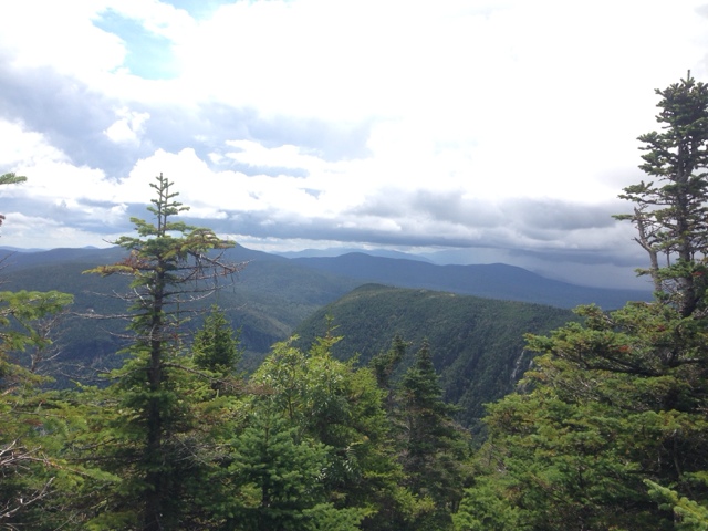
John and Cindy rented an amazing place in Rangley. We had a fantastic view of the lake and mountains. 
Rangley Lake 

Cindy and John put out a huge lunch spread. We took turns showering and stuffing ourselves. 
Lynn and Cindy

Once we were properly stuffed and clean, we started a load of laundry and relaxed. We spent time planning out our next few stops and decided that we were still on schedule. The Sterman's drove us to the grocery store so we could resupply. It was nice to go to a proper grocery store again. 

Once back at the condo, we immediately began repackaging our food and loading up our food bags. With that task complete we could sit back and relax. I had to sew up my running shorts. All of the sitting down and sliding over rocks had taken its toll. I repaired some of my other gear and before I knew it dinner was being prepared. There were too many cooks in the kitchen, so my help was not necessary. I sat outside and enjoyed the view from the patio. 

The dinner spread was very impressive. We had hamburgers, bratwurst, coleslaw, grilled onions, grilled pineapple, guacamole, corn, and a few different types of salads. There was a ton of leftovers, they really knew how to feed hungry hikers. After we were all properly wined and dined, it was time for brownies and ice cream. Man, I was bursting at the seams. We all helped clean the kitchen and then it was time for bed. The beds were very comfy and I was asleep in minutes. 

Dinner spread

"Learning to navigate the unpredictable terrain of life is an essential skill to develop. We can't live a happy life if we are unwilling to pave the path that will lead to our personal fulfillment and destiny. Learning to sit comfortably in the seat of uncertainty is challenging, but equally rewarding, because discovery is what waits just underneath the surface of that uncertainty and that gives us the chance to become fearless explorers, of our own lives." -Jaeda DeWalt


Day 149- There Is Light At The End Of The Tunnel

Aug 28, 2015
Speck Pond Shelter(1917.4) to Fyre Notch Lean-to(1927.8) 10.4 Miles

Today marks the last section of my Guthook trail guide app. I have used Guthook for all of my elevation profile pictures. It is a great app if you are thinking about thru-hiking the AT or the PCT. 

Last night was cold! I felt like I was back in the Smokies, except I stayed warm last night thanks to my underquilt. This morning was a different story though. There is nothing worse than having to put on cold, wet clothes in the morning. It was about 50 degrees when I got up at 6:00. I'm not sure how cold it was with the windchill though, probably in the low 40's. I ate breakfast and made coffee, but it took me awhile before I forced myself to put on my wet clothes. I didn't actually leave camp until 7:30. I was dreading today. I was cold, wet, tired, and utterly demoralized. The terrain over the last three days has been miserable. It was much harder than anything I have done so far. After only a few minutes into this mornings hike I was honestly ready to quit. I considered slack packing, yellow blazing, or just quitting all together. We have all been pretty miserable the last three days. I was tired of feeling like I could die or be seriously injured with every step I took. This morning was no different. After leaving the shelter I only had to climb 600' over 1.1 miles. Sounds easy, right? Wrong!!! I had to climb up a crumbling trail, through the mud, and up wet rock slabs. The only  way to describe this challenge is for you to imagine a 15 foot stainless steel slide. Now picture that slide at a 60 degree angle, perched on the side of a dark, misty mountain. Before you try to climb up the slide, pour bacon grease mixed with mud down it. Now go ahead and climb up it. At the top will be a large muddy puddle with tree roots mixed in. Once you have your footing beneath you, look up, there is another slide to climb up. That is what I have been dealing with for the last twenty seven miles. Think that's bad? Try going down that. Today was even more fun because as I neared the top of the climb, I was above treeline. I had to contend with that madness, with 30-40 mph winds tossed into the mix. By the time I reached the top, I was at my wits end. I could not take another day of that type of terrain. My plan was to hike the 2.5 miles, all downhill, to Grafton Notch. From there I was going to hitch to the nearest town, get a nice hotel room, take a hot shower, and eat a lot of food. After that I would decide on how I would proceed. 
A break in the mist

As I turned the corner from the summit of Old Speck mountain, the craziest thing happened, I began to hike on actual trail. It was lovely! I kept expecting for it to go away and turn into something from ,Dante's Inferno, again. The farther I hiked, the nicer the trail became. I almost cried, I was so relieved. 
The sun even came out to play

I caught up to Airlock right around this time. We both agreed that our change in fortune came not a minute too soon. 
I had just asked her how she felt about the change of trail conditions
Actual, bygod trail

I had heard that the descent into Grafton Notch was really difficult. That couldn't have been further from the truth. It was a very enjoyable hike. To make things even better, the parking lot there even had a trash can and a privy. There was a trail maintainer that gave us clean filtered, non yellow water. I yogied(got food from a tourist without actually asking them for food. Like yogi bear) some almonds off of a day hiker. The sun was shining so bright that I was able to dryout all of my wet gear in a matter of minutes. It was amazing how quickly my entire world was changed. 
Nice trail 
Versus
Evil trail

The day only got better from here on out. We climbed up Baldpate Mountain, and we were rewarded with amazing views for our effort. The climb was long, with a lot of elevation gain, but since it was over nice trail I couldn't have cared less. It felt great to stretch my legs out again. I actually hiked 2.6 mph for the first time in forever. My ankle still hurts, but even that seemed manageable. 
View from Baldpate West Peak
Looking at Baldpate East Peak

The hike up to the east peak was a blast. We went up the rock faces seen in the picture above. They were more like ledges that were fun to hike on. 
Where's Waldo(or Airlock) 
She is the tiny blue and orange dot in the center of the picture on the lowest rock face

Fun ledges
Mt. Washington and Jefferson barely visable in the distance 
View back to Baldpate West Peak

The trail for the next mile returned to nasty, sketchy, unpleasant trail. We were a little frustrated by it, but somehow it didn't seem as horrible. I guess because we knew it wouldn't last. Hopefully from here on out, it will be hard climbs up tall mountains, but with nice trail conditions. I've heard that the nasty trail doesn't completely go away for the next 28 miles, but it is just in small sections. I was definitely taken to my breaking point the last few days. I honestly don't think I could have taken another full day of that crappy terrain. The AMC(known to thru-hikers as the Appalachian Money Club) should be ashamed of themselves. They charge us $8 to camp at shelters, they treated us poorly throughout The Whites, and they fail at even coming close to maintaining a safe, hikable trail. I'm not asking for easy, if it was easy everyone would do it. I'm just asking for a safe hiking trail. Ok, rant over with.... for now. 

Tomorrow is a new day and I'm hopeful for what lies ahead. 256.4 miles left until I reach the base of Mt. Katahdin!!!! 

"Today, you've got a decision to make. You're gonna get better or you're gonna get worse, but you're not gonna stay the same. Which will it be?" -Joe Paterno


Friday, August 28, 2015

Day 148- The Hardest Mile Of The Appalachian Trail

Aug 27, 2015
Full Goose Shelter(1912.3) to Speck Pond Shelter(1917.4) 5.1 Miles


Today we did the hardest, or if you have the right attitude, the most fun mile of the AT, Mahoosuc Notch. Guthook describes this section as, "a deranged jumble of boulders at the bottom of this deep cleft between Mahoosuc Mountain and Fulling Mill Mountain". The notch is one mile long and takes anywhere from 2-5 hours to complete. We decided to tackle it as a group because in some places it is necessary to take your pack off and push or pull it through the crevices. 

Due to the insane amount of college kids at the shelter last night we decided to get up early so we could beat them to the notch. I was up at 5:30 and made sure to make a lot of noise to wake up the kids next to me. They didn't seem too happy for such an early wake up call. Airlock and I were the first ones out of camp, but 2 Bad Dogs and Cruise Control were only a few minutes behind us. The first 1.5 miles of the day were exactly like yesterday, very slow going. 

We made it to the top of Fulling Mountain after a lot of effort, but there wasn't a view to be had. We did see a rock cairn that looked like a dog though. 
Doggy rock cairn

After a steep descent over slick boulders we finally made it to Mahoosuc Notch. I was determined that no matter how hard it turned out to be, I was going to have fun. 
Mahoosuc Mountain
Fulling Mill Mountain

Mahoosuc Notch lived up to expectations. I had a blast, but it was really hard. It took us 2.5 hrs to make our way through. I was glad we went through as a group. Although it took us longer to make it through as a group, the moral boost of being together was great. It also allowed for us to find better ways to make it through. 
2 Bad Dogs, Art taking his pack through
Sketchy section
I got mad selfie skillz: Me, Cruise Control, Airlock, Art, Lynn(2 Bad Dogs) 

I've been looking forward to the Notch since Georgia, but I'm glad to have it behind me. My ankle really hurt after all of the twisting, turning, and climbing. 

After making our way through the jumble of boulders we had to climb up Mahoosuc Arm. The climb up the Arm was 1,500' of elevation over a little less than a mile. Most of the climb was up large slippery boulder slabs. I'll be glad when I can be a hiker again instead of a rock climber. 
I climbed up this vertical wall of rock
Looks like fun, right: They should call it Mahoosuc(k) Arm

By the time I made it to the top, the fog and mist was all gone and I got a spectacular view. 
Mahoosuc Arm

As hard as the climb was, I actually enjoyed it. Yes, it sucked and yes, it was really hard, but I would rather climb up all day than go downhill. 
Old Speck Mountain(I'll climb that tomorrow)

The descent down to Speck Pond shelter wasn't too bad. I was also exited that we were only .9 miles from our campsite. We knew that today was going to be really difficult, so we planned an extremely low mileage day. We were hoping for nice weather so we could swim in the pond, but that didn't happen. It was a really nice day, but it was really cold out. 
Speck Pond 

I'm not sure it got above 55 degrees today. Maybe it was in the mid 60's, but with the wind chill it was cold. Tonight is going to be in the low 40's, with a windchill of 25-35 degrees. Thankfully we got to camp ridiculously early, 2:30, and got setup before the large groups came in. Cruise Control and I are sharing a tent platform even though we both use hammocks. There was no where else for us to hang. Airlock and 2 Bad Dogs took the other two platforms for themselves. I had Mac&Cheese for dinner, but I was still hungry so I cooked some noodles too. Then I had some cookies, trail mix, and a snickers bar. I guess I worked up an appetite today. 

Hopefully the trail will get a little easier soon. I'm over these ridiculous boulder/rock climbing sections. Going .75 miles per hour is exhausting. I'm not expecting things to be easy, I'm just asking for some proper trail conditions again. 

"Write your injuries in dust, your benefits in marble." -Benjamin Franklin


Wednesday, August 26, 2015

Day 147- The Last One

Aug 26, 2015
Gentian Pond Shelter(1902.7) to Full Goose Shelter(1912.3) 9.6 Miles 


So much for a relatively easy day. It took us over ten hours to go 9.6 miles. There is a common saying along the AT, "No pain, no rain, no Maine". Well today there was plenty of pain and rain, but at least we finally made it into Maine.  
13 states down, 1 to go

Since we had an "easy" day planned, everybody decided to sleep in. I was up at 6:30, but didn't make any moves to get up until 7:00. I quickly packed up and made my coffee. I was going to drink it by the pond, but I was informed that there wasn't any wild life hanging out there. For the first time ever, I beat Airlock out of camp! It wasn't by much, but nonetheless it happened. 

The first climb of the day was pretty hard. Mt. Success kicked my butt. It was mostly steep boulder scrambles over wet rock. Boulder scrambles have quickly lost there appeal. Halfway up the mountain I was a muddy, soaking wet mess. Every time I thought I had made it to the top, it kept going. At one of the false summits I came across, 2 Bad Dogs, they were sitting down eating breakfast. I asked them if we were at the top yet and they said no. They thought they were at the top of Mt. Success, but decided they must have been at the top of Mt. Failure. I got a laugh out of that at least. 
Terrain going up Mt. Success
Amazing view

The day just went downhill from here. Every time we went up it was over rock faces for a few hundred feet. Then we would turn around  and go down rock faces for a few hundred feet. 
Ugh
Not even sure how we managed this

A few times the terrain was so rugged, we had to take our packs off and hand them down to one another. This terrain is really difficult, but with a sprained ankle it is miserable. It is really hard to get leverage going up the rock faces without putting a lot of force on your ankles. Not exactly ideal for me. I'm not sure which hurt more, going uphill or downhill. 
Team building exercise, passing packs down

Just before we crossed the border into Maine, it started pouring. It made it hard to take pictures, but in the end I made it work. We all wanted to stop and eat lunch, but the rain made it really difficult to take a break. We pushed on as long as we could, eventually the rain slowed down to a drizzle and we ate lunch on the side of the trail. 

The remainder of the day was up and down sketchy, dangerous sections of trail. 
Rebar drilled into rock face to help
Bog boards going downhill 
Sometimes all you can do is sit down and slide
We came down that exposed rock face

By the time we finally made it to the shelter everyone was ready for the day to be over. All I wanted was to wash the mud off of me, a hot meal, and to go to bed. Unfortunately, the shelter and tenting area was over run by three different groups of college kids. It's going to be a long night. I searched everywhere for a place to hang my hammock, but the only place I could find is five feet away from the college kids. It's almost ten o'clock and they are still up. Obviously they don't understand the concept of hiker midnight. I doubt they will enjoy the 5 am wake up call I have planned for them. 

"Tough Times Never Last, But Tough People Do!" - Robert H. Schuller

Tuesday, August 25, 2015

Day 146- Back In The Saddle

Aug 25, 2015
Hogan Road(1891.6) to Gentian Pond Shelter(1902.7) 11.1 Miles 


I did not sleep very well last night. It was probably a combination of things. The hostel was located right on US 2, which is a very busy road. I kept waking up every time a big truck went by. I was also anxious to get hiking again. I wasn't sure if my ankle was ready to get going again, but I sure was. I woke up at 3:30 and slept off and on until 5:45. When I finally got up the only other person awake was Airlock. I took a shower and walked down the street to meet her for breakfast. I ordered two chocolate chip banana pancakes and a cup of coffee. The pancakes were enormous. I ate one there and saved the other one to eat on the trail. As we were eating, 2 Bad Dogz, came in. We chatted with them for a little while before heading back to the hostel. We only had a few minutes to get packed up and ready to go before our shuttle was ready to leave. I got dropped off at Hogan Rd, where I got off a few days ago, but Airlock and Cruise Control had to go back to the US 2 trailhead parking lot. 

As I started hiking my ankle was really sore, but I had expected that to happen. What I didn't expect was how sore my knees and calfs were. After sitting around for three days my whole body had tightened up. There is nothing like a 2,000' climb to get your muscles loosened back up though. The terrain was ok at first, but then it quickly shifted from dirt and roots, to exposed slabs of rock. I had a tough time getting enough traction on the wet rock. I ended up having to put more weight on my ankle than I would have liked, but it worked out ok in the end. The weather forcast called for rain most of the day and it began halfway up the mountain. It wasn't enough rain to get me soaking wet, but it was enough to make all of the rocks really wet and slippery. 
Hiking through a cloud
View from the top

It didn't take very long for Airlock and Cruise Control to catch up to me. After climbing up Mt. Hayes, the trail began to go downhill. As I was carefully making my way down, I heard, "Hellllllooooo," from behind me, it was Airlock. I have really missed hearing our trail greeting for one another. I wasn't the least bit surprised that she had caught up to me so quickly. As Iron Lady put it a few days ago, "I'm a broken machine." 

We didn't hike together for very long. Instead we flip flopped back and forth all day. Airlock and Cruise Control move pretty fast over wet slippery rocks, but I was still a little faster than them going uphill. Every hour I tried to stop and take a break to let met ankle rest. 
  Reminded me of Jurassic Park 

Halfway through the day the rain began to pick up. We could hear thunder, but thankfully it was in the distance. We skipped eating a proper lunch, opting for quick snack breaks instead. 

I hiked on when Cruise Control and Airlock took one of their snack breaks. I had run out of water and needed to hit up the next water source before I stopped again. Luckily, I didn't have to go far, but unluckily the water was yellow after I filtered it. Oh well, it tasted fine and reminded me of the water from NY and NJ. After my water stop I had planned on taking a break at the 1,900 mile mark. I figured that I would have to make the sign since I've made every single one since 1,000. To my surprise, it was already done. In fact, there were two different 1,900 mile markers. 
Simple, but nice
Somebody made this one out of moose poop

It was nice not having to stop in the pouring down rain to make the sign, but I kind of missed putting my own spin on it. 
Now I have less than 289.2 miles to go! 

The last few miles to the shelter were pretty uneventful. I managed to make it the whole day without falling. I was very pleased with myself. Especially because Airlock fell once, for only the eighth time this entire trip, and Cruise Control fell a couple of times. 
Sample of today's terrain

I did have a few moments of panic though. I had to cross a ton of bog boards towards the end of the day. I went over them really slow, thoroughly testing out each board before putting all of my weight on it. 
PTSD

We made it to the shelter really early. We had all of our camp chores done by 4:00. We could have pushed on and made it to the next shelter, 5 miles away, but we were all tired, hungry, wet, and cold. So we agreed to stick with our original plan and camp here. Tomorrow will be another "easy" day since we only have to hike ten miles. The plan is to sleep in tomorrow. There is a pond next to the shelter and we are hoping that if we go down there to drink our coffee/tea in the morning we might see a moose. Rumor has it there is one roaming around this area with a baby calf.   

"The answer to three questions will determine your success or failure. 
- Can people trust me to do my best? 
 - Am I committed to the task in hand? 
 - Do I care about other people and show    
    it?
If the answers to all three questions are yes, there is no way you can fail." - Lou Holtz